• Skip to primary navigation
  • Skip to main content
  • Skip to primary sidebar
  • Home
  • What is a Personal Locator Beacon?
  • Register Your PLB!
  • How to test a PLB
  • How PLBs Work

PLB Review - Personal Locator Beacon Reviews

Get Rescued - Own a PLB

  • 2022 ACR ResQLink Review
  • ACR Aqualink Review
  • 2022 ACR ResQLink View Review
  • 2022 McMurdo Fast Find 220 PLB Review

Personal Locator Beacon Articles

Colorado Hiker Saved by PLB

By Eric

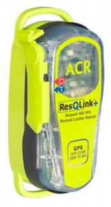
ACR Resqlink PLB
ACR PLB-375 ResQLink+

On August 15th 2015 a 60 year old, avid hiker and backcountry skier activated his ACR PLB-375 ResQLink at noon.

He had been hiking near Shoshoni Peak in the Colorado Mountains North West of Denver and ran into trouble. He had injured his head and sustained other injuries while chasing his dog! While his injuries were somewhat minor, he was located at over 11,000 feet in the mountains and unable to traverse the many miles that it would have taken him to get to civilization.

The ACR PLB-375 has an internal GPS receiver which sent his location along with the distress signal to the Air Force Rescue Coordination Center.

The AFRCC contacted local authorities who unsuccessfully attempted to rescue the hiker using a Life Flight helicopter. A military Black Hawk helicopter was dispatched and the hiker was extracted to safety at 4:30 pm.

In order to help rescuers determine exactly what is going on and perhaps narrow down your planned activities, it is extremely important that you properly register your PLB!
 

Filed Under: PLBs Save Lives Tagged With: Personal Locator Beacons In Action, PLB-375 ResQLink+

Boy Scout Leader with Heart Trouble Rescued by PLB

By Eric

ACR Resqlink
ACR PLB-375 ResQLink+

A Boy Scout Group of 18 kids and adults was on a 50 mile hike near Upper Cathedral Lake in Okanogan County, Washington, when one of the adults began having heart trouble.

An ACR PLB-375 ResQLink with an internal GPS receiver was activated 10:15 am. When activated the ACR PLB-375 sends its GPS location along with the distress message.

After receiving the alert through the SARSAT System the Air Force Rescue Coordination Center coordinated with local authorities about available search assets. The local Sheriff coordinated with a Federal aviation unit to search for the PLB and party using a Black Hawk Helicopter.

The Black Hawk landed near the group at 2:05 pm, loaded the individual and his child and evacuated the man to a medical facility.

Often in situations like this during its rescue process the AFRCC consults the PLB Beacon Registration Information that is sent to them with the distress message and beacon location. They will attempt to contact the owner or designated contacts to try to determine if the distress signal is real and if there is any available information on what beacon owner is doing as well as any known medical issues. This can greatly increase the rescue forces response time!

Filed Under: PLBs Save Lives Tagged With: Personal Locator Beacons In Action, PLB-375 ResQLink+

How and Why to Register Your Personal Locator Beacon

By Eric Leave a Comment

Personal Locator Beacons or PLBs are a great lifesaving device which can bring rescuers right to your location in the event of an emergency. Just like Emergency Locator Transmitters (ELTs) on aircraft and Emergency Position Indicting Radio Beacons (EPIRBs) on boats, once activated PLBs transmit a digital signal to the SARSAT System. This signal contains information which positively identifies the individual beacon which has been set off (sort of like a serial number). The signal might also contain your GPS location, if your PLB has a GPS function (this is the best kind of PLB to buy!). If your PLB doesn’t have GPS then the Satellite system will have to try to determine as accurately as possible by itself.

In an emergency NOAA is your friend!

In the United States the National Oceanic and Atmospheric Administration (NOAA) is the agency which monitors and receives signals from the SARSAT satellite system when distress beacons like Personal Locator Beacons are set off.

When NOAA receives a signal that a PLB has been set off the message sent by the PLB contains the information that l mentioned above. Which if it doesn’t contain GPS data is not a lot to initially go on, it could take the satellite system an hour or more to determine exactly where your PLB is located if it has no internal GPS data. In an emergency situation minutes can save lives, so it’s important for rescuers to determine as soon as possible exactly what is going on.

In order to accomplish this NOAA maintains a registration database of all of the emergency beacons (PLBs, ELTs, and EPIRBS) in the United States. Beacon owners can send in both their contact information and info on their emergency contacts via several different means.

While registering your 406MHz distress beacon is the smart thing to do, you are actually required to do so. You could in fact receive a penalty or fine if you don’t register it and then use it!

Instant Information for Searchers

When you set off your Personal Locator Beacon (in a distress situation) the signal I mentioned is sent to the satellite system which then sends it to NOAA ground stations (in the US). Once received the PLB’s message is then automatically paired with its registration data from the database and forwarded to the US Air Force Rescue Coordination Center (AFRCC).

The AFRCC then immediately begins to try to determine if someone is actually in distress or if the alert is a false alarm (the majority are). They do this by attempting to call the beacon owner with the information on the registration. They’ll try your home, cell, work numbers (whatever you’ve given) to attempt to contact you. If they can’t reach you they’ll move on to the alternate contacts to see if they know what you are up to. These contacts should be people who will know what you are doing and where you’ll be i.e. you are out hiking and in what area.

You should list family and/or friends that can be easily contacted (e.g., carry a cell phone, or are usually available at work or at home) and would have knowledge about where you camp, hunt, fly, etc.

Finding out this way that you actually or might be in an emergency situation is the fastest way to get help heading your way when needed!

An Information Age

The beauty of the NOAA Online Beacon Database is that you can log back in at any time to update your information based on what you are doing. You should also update your entries when you or your contacts change addresses or phone numbers or you want to change who will be an additional contact for you.

Besides general contact information, you can also input how you plan to use your PLB, such as Hiking, Hunting, Fishing, or Other (with a spot to say what that is). There is also section for “Additional Data”, here you can enter a paragraph with much more detail about your plans. The more specific the better and because you can update your registration at any time you can change it based on what you are doing. Here are a couple of examples of what you could enter under additional data:

  • I’ll be hiking south on the Appellation Trail starting on May 1st at Mount Katahdin Maine. I plan to travel 15 miles per day and hope to finish by the end of September in Georgia.
  • I’m camping in Glacier National Park Montana from 5 through 12 August.
  • I use my PLB while hunting on and around Beartown Mountain State Park in Berkshire County Massachusetts during the fall. In the summer I take it whitewater rafting on the Arkansas River in Colorado.
  • This PLB is used as an emergency backup to my aircraft ELT on tail number N12345C, my home airport is Dayton Wright Brothers Airport (KMGY).

These are just a few examples, you can enter anything that you think would help those trying to assist you. This info is just to get help heading in the right direction in the initial uncertainty period, especially if the satellite system hasn’t reported your location yet. Stating what you are doing on your registration lends credence to the thought that this is actually a real emergency versus a false alarm, which most beacon activations are.

The NOAA Database

Every Personal Locator Beacon which is sold comes with NOAA registration paperwork, which can be completed then faxed or mailed in. Or PLB owners can go online and register their distress beacon immediately. Faxed and mailed registrations can take up to two business days to process once received by NOAA, online registrations take effect immediately.

Registration is free of charge!

The mailing address for Beacon Registrations is:
Department of Commerce
National Oceanic and Atmospheric Administration
SARSAT Beacon Registration
NSOF E/SPO53
1315 East West Hwy
Silver Spring, MD 20910-3282

The Registration Fax number is: (301) 817-4565

The web address for beacon registration is: https://beaconregistration.noaa.gov/rgdb/ Click on “New Registration.”

PLB owners who mail or fax in their registrations can go to the same web address afterwards to set up online access to their registration data.

Here are links to blank forms:

PLB Registration Form: https://beaconregistration.noaa.gov/rgdb/forms/plb.pdf (Handheld Beacons)

ELT Registration Form: https://beaconregistration.noaa.gov/rgdb/forms/elt.pdf (Aircraft Mounted Beacons)

EPIRB Registration Form: https://beaconregistration.noaa.gov/rgdb/forms/epirb.pdf (Boat or Vessel Mounted Beacons)

The registration information, and the corresponding proof-of-registration decal, is valid for two years.  The FCC requires that you renew your registration every two years.  However, you are encouraged to provide updates to your registration anytime it’s required.


This site recommends that you buy a PLB with GPS capability!


Filed Under: Personal Locator Beacons Tagged With: PLB

How do I test my Personal Locator Beacon?

By Eric Leave a Comment

How do I test my Personal Locator Beacon?A very good question.

It is very important to check your Personal Locator Beacon properly. Especially before you head out into a potentially risky situation.

Personal Locator Beacons should never be activated unless you are in grave and eminent danger.  So do not push the ON or Emergency Button. Only use the test button.

The reason that you should never activate your PLB, no matter how briefly, is that the emergency signal will be picked up by the Search and Rescue Satellite System. Rescue forces will then attempt to contact you and if they can’t they will come looking for you.

This happens on a daily basis in the United States taking up the time of rescue workers who try to determine if each and every distress signal that comes in id real or not. Don’t contribute to this problem!

406 MHz emergency beacons should only be tested using the “self-test” feature of the beacon or the beacon should be taken to an authorized dealer or test facility. Check the documentation that came with your distress beacon on how to test your specific model correctly.

If you do accidentally activate your beacon you should call the U. S. Air Force Rescue Coordination Center at (800) 851-3051 to advise them that you have set off your PLB accidentally. They will want to know your PLB’s 15 digit Hexidecimal ID (some manufacturers call this the UIN).

A Personal Locator Beacon is a great Safety Device, and should be treated responsibly.

Also be sure to register your Personal Locator Beacon!


This site recommends that you buy a PLB with GPS capability! Don’t try to save a few bucks, you life is worth much more!

Filed Under: Personal Locator Beacons

How Do PLBs Work

By Eric Leave a Comment

Personal Locator Beacons, commonly called PLBs are small handheld devices which, when activated will send an emergency message to Search and Rescue Forces if you get into an actual emergency situation.

PLBs are a fairly new addition the safety tool box which everyone who spends time outdoors, especially those who do risky activities away from civilization, should carry.

A Personal Locator Beacon when activated sends out an emergency signal which can be picked up by a worldwide satellite system, which then forwards the message to ground receivers and the appropriate Rescue Control Center (RCCS).

These RCCs will then dispatch Search and Rescue (SAR) Teams to assist you. PLBs should only be activated in an actual emergency situation as rescue workers will come looking for you.

The purpose of this article is to outline, in simple terms, just how it is that when you  push the button on your PLB, that a Search and Rescue (SAR) Team will come looking for you at your location.

The Personal Locator Beacon

With the push of a button, you are able to send a call for help to SAR Teams. What an amazing and potentially lifesaving ability. But how does this happen?

PLBs as well as their aviation (ELT) and Marine (EPIRB) counterparts, when activated send digital a signal on 406 Mega Hertz (MHz) to the SARSAT Search and Rescuer Satellite system. This 406MHZ encoded data burst can send various bits of information (depending on the type of beacon you have) which the SARSAT system picks up and decodes.

Personal Locator Beacons come in different varieties:

  • Very Basic PLBs which only have the 406MHz transmitter – These are the least expensive type
  • Some models have the 406MHz transmitter  plus a 121.5MHz “homing” transmitter – This allows rescuers to home in on your location once they are nearby
  • Some PLBs have an internal Global Positioning System (GPS) receiver – this allows the PLB to transmit your actual location with the distress message
  • The best models have all of these functions!
  • There are other options offered on some brands which while cool, do not affect the actual operation of the beacon in normal conditions. Options like – waterproofing, an internal strobe light, belt clips, etc.

The Satellite System

When you activate your PLB it sends out its signal on 406MHz (that is a frequency, like the different radio station frequencies on your car radio). There is an international system of satellites orbiting the earth listening for these signals.

The Search and Rescue Satellite System, or SARSAT System is a collection of receivers on various types of satellites. These satellites have many other devices onboard and perform many functions, but the only one we are concerned with is the SARSAT package.

I’m going to have to get a bit technical here on the different types of satellites, so bear with me this is important to how quickly someone will be able to assist you in an emergency. The speed of your rescue depends on both the type of PLB you’ve purchased and the type of satellite which picks up your signal. If you want to skip most of this section, make sure you read the KEY POINTS!

At the time I’m writing this there are 2 types of SAR Satellites, Low Earth Orbit and High Earth Orbit. A third, Mid Earth Orbit is in the works.

  • Low Earth Orbit (LEO) Satellites 
    • LEO Satellites orbit the earth in what is considered a “low orbit.”
    • LEO Satellites are in “polar orbits”, meaning they fly at a right angle to the earth’s equator, so on one orbit they fly northwards and then over the north pole and continue on southwards until they fly over the south pole and continue on northwards again.
    • As the LEO Satellite is orbiting south to north – north to south, the earth is spinning below the satellite. So the satellite flies over a different ground path on every orbit.
    • There are currently 6 LEO Satellites in the SARSAT System.
    • Because of their altitude LEO Satellites “view” a small area as the sweep over the earth.
    • LEO Satellites receive distress signals and transmit them to the ground stations if they are in view. They then store the message and transmit it to other ground stations as they pass over.
    • KEY POINT – Because LEO satellites move in relation to the earth below they can use Doppler Shift computations to determine the point on the earth from which a distress signal it is receiving is coming from. Simply, they have a way to determine where your PLB’s emergency signal is coming from.


  • High Earth Orbit (GEO) Satellites
    • High Earth Orbit satellites are placed in what is called Geostationary Orbits (called GEO for geostationary).
    • GEO Satellites sit at a height at which the speed they orbit keeps them always stationary over the same geographic point – Geo Stationary.
    • GEO Satellites orbit over and parallel to the equator.
    • There are currently 8 GEO Satellites in the SARSAT System, a 9th will come online soon. Only 4 are kept fully operational an one time.
    • Because of their altitude GEO Satellites “view” a very large area of the earth that that they are parked over which is always in view. This is why only 4 are needed.
    • GEO Satellites receive distress signals and immediately transmit them to the ground stations in view.
    • There is a GEO Satellite parked where it can view the entire United States.
    • KEY POINT – Because GEO satellites DO NOT move in relation to the earth below they CAN NOT use Doppler Shift computations to determine the point on the earth from which a distress signal it is receiving is coming from. Simply, they DO NOT have any way to determine where your PLB’s emergency signal is coming from.


How the PLB and the satellite work to together

As I mentioned before, the type of Personal Locator Beacon you buy could affect the speed at which rescue forces begin to head out to help you.

Why is this? Read on…

Remember there are different kinds of Personal Locator Beacons based on what features they have. The two that matter for this topic are PLBs without GPS capability and PLBs with GPS. And there are two kinds of SAR Satellites, LEO and GEO.

First, let’s discuss a PLB without GPS capability.

If you become injured or stranded in an emergency situation and activate your distress beacon without GPS the GEO satellite which covers your area will pick up the signal. But all a PLB without GPS sends is its identifier.

The GEO satellite has no way to determine where the PLB is located. So all rescue forces will know is that that beacon was activated but not where it is. Hopefully you’ve registered your PLB and some contact information is also sent with the distress message to help determine where you might be.

Without knowing your location there is nothing Search and Rescue forces can do!

They have to wait for the next part of the system, the LEO Satellites, to come into play. LEO satellites can determine your beacon’s location, but because of orbital mechanics it could be up to an hour and a half before one flies into a position where it can hear your PLB. Any response to your call for help could be delayed that long!

Also determining your location in this manner is not very accurate and it could take several passes from different satellites to get a valid usable location.

Now, let’s discuss a PLB with GPS capability.

In the same scenario, once you activate your distress beacon with GPS the GEO satellite which covers your area will pick up the signal. But this time your PLB sends not only its identification, it also sends your GPS location.

Rescue workers can then easily make a quick determine if you potentially are in distress. For instance, if you are located in a wilderness area, then you most likely are having an actual problem. But if you are located in a parking lot outside an Outdoor Man Store then you most likely turned your PLB on to “test it” without having read the directions.

A LEO satellite picking up your signal will also receive your GPS location.

So as you see having a Personal Locator Beacon with GPS capability can greatly improve your chances of being rescued in a timely manner. And let’s face facts, when you are hitting your emergency button on the PLB, asking for someone to help you, time most likely is of the essence.

This site recommends that you buy a PLB with GPS capability! Don’t try to save a few bucks, you life is worth much more!

Register your PLB


Check out the PLB Selection


Filed Under: Personal Locator Beacons Tagged With: PLB

What is a PLB or Personal Locator Beacon?

By Eric Leave a Comment

Personal Locator Beacons which are usually just referred to as PLBs are a fairly new addition the safety tool box which everyone who spends time outdoors, especially those who do risky activities away from civilization, should carry.

If you end up in an emergency situation out in the wilderness a PLB in your pocket or backpack could be your only hope of rescue.

What is a PLB and how does it work?

Simply put, Personal Locator Beacons send an emergency signal through a worldwide satellite system to the appropriate Rescue Control Center (RCC). These RCCs will then dispatch Search and Rescue (SAR) Teams to assist you with your emergency situation. PLBs should only be used in an actual emergency situation as rescue workers will come looking for you when you activate your beacon.

Never turn your PLB on just to test it, this will cause an actual distress message to flow through the SAR System. There are proper procedures outlined in your beacon’s instructions which if followed properly will allow you to test the PLB without giving off a false alarm.

PLBs were once large and bulky devices, but as technology has improved manufacturers have been able to reduce the size of their products. Your average PLB is now as small as the average flip style cell phone, they will easily fit into your backpack or pants pocket.

Who should carry a Personal Locator Beacon?

Anyone who enjoys activities that are slightly dangerous or which place them well off the beaten path should definitely carry a PLB.

Here are some examples of who should carry a Personal Locator Beacon:

  • Hikers
  • Campers
  • Hunters
  • Horse Riders
  •  ATV Riders
  • Snow Machine Riders
  • Skiers and Snowboarders
  • Climbers
  • Kayakers
  • Jet Ski Riders
  • Boaters
  • Fishermen
  • Ice Fishers
  • Those who often travel in areas without cell coverage

As you can see from the list, anyone who is out by themselves or with a small group away from other people should carry one, especially if they know cell coverage is spotty or unavailable where they are going.

How much is your life worth?

Over the last few years PBLs have not only become smaller, but they’ve become cheaper and filled with more bells and whistles.

You can get reliable PLB from online stores like Amazon.com for as little as $275. A small price to pay to know that rescue forces will be headed you way if you need them.

How will they find you?

OK, so you’ve fallen and you can’t get up, to use the line from the TV commercial, you’ve had an accident out in the wilderness, here is how a PLB can help you.

Perhaps you were hiking in the Colorado wilderness by yourself, far from any other person, when you slipped and fell. Your leg got caught, twisted, and broken severely under a rock. You are miles from anyone else, you are stuck and there is no way you can get yourself out and no one will be passing by to find you.

In an older time you’d be out of luck, you’d die right there where you lay. But you have a technological marvel packed away in your backpack, your PLB. You pull it out, open it up, and turn it on. Within seconds the Search and Rescue Satellite system will pick up the Personal Locator Beacon’s signal and alert the authorities that someone needs help.

Depending on the type of PLB you’ve purchased, either the PLB will send your GPS location to the system, or the satellite system will determine your location on its own.

In either case after you bought it you should have registered your Personal Locator Beacon, in the United States this registration data will be transmitted along with the PLB activation information to the U. S. Air Force Rescue Coordination Center (AFRCC).

Rescue is on the way

The AFRCC will attempt to immediately contact you or those you’ve listed as contacts on your PLB Registration via phone to determine if you are actually in a distress situation. They make these calls because most beacon activations are false alarms and they need to determine if your emergency signal requires that someone respond. If they find out that you are or could be in an emergency situation or they can’t contact anyone they will get SAR forces headed to the location of your Personal Locator Beacon’s signal as fast as possible.

Be Prepared

Scenarios just like this one play out all the time, so make sure ahead of time that if you were to find yourself in a bad situation that you would have the right tools in order to bring about a good ending.

Buy yourself a PLB!


More Information

In other areas of this site you find much more information on how PLBs work, how the Search and Rescue Satellite System works, How to properly operate your Personal Locator Beacon, How to test your PLB, What is the best type of PLB to buy and most importantly our Personal Locator Beacon Review area, where you’ll be able to get our honest opinion of the various PLBs available on the market and where you can get them at a reasonable price.

Our goal is to be your best resource for information on Personal Locator Beacons! Writers for this site have worked in the United States Search and Rescue community for many years and have extensive knowledge of how the COSPAS-SARSAT system and America’s SAR System works. Rest assured we won’t steer you wrong. We fell that a PLB should be carried by everyone who engages in risky pastimes and those who spend time well away from others in areas of limited cell coverage.

This site is also committed to reducing the very large amount of false activations which take up a huge amount of our nation’s Search and Rescue professional’s time. PLBs are not toys and should be used and tested properly. It is every owners responsibility to learn about their beacon so as to prevent themselves from setting off a false SARSAT alarm.


This site recommends that you buy a PLB with GPS capability!

Filed Under: Personal Locator Beacons Tagged With: PLB

The COSPAS-SARSAT Satellite System

By Eric Leave a Comment

This page started out real dry and technical, but I’ve totally reworked it to make it more assessable and easier to read. This section will give you the background necessary to understand the recommendations which come later in the e-book on how to increase your odds of being saved from a distress situation.

The greatest aid to both searchers and those needing to be rescued is the Cospas-Sarsat system. This is a system of satellites orbiting the Earth combined with ground stations which are designed to provide distress alerting and location data to assist search and rescue (SAR) operations. This is accomplished by receivers on the satellites which detect and locate the signals of distress beacons operating on a frequency of 406 Megahertz (MHz). The position of the distress and other related information is forwarded to the appropriate Rescue Coordination Centers (RCCs) through the Cospas-Sarsat Mission Control Center (MCC) network.

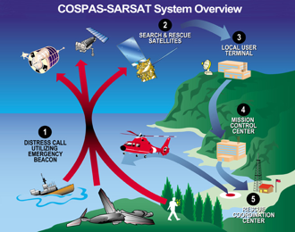
The basic Cospas-Sarsat concept is illustrated in this figure. The System is composed of:

COSPAS-SARSAT Overview
1. Distress radio beacons (ELTs for aviation use, EPIRBs for maritime use, and PLBs for personal use) which transmit signals during distress situations.
2. Instruments on board satellites in geostationary and low earth orbits which detect the signals transmitted by distress radio beacons.
3. Ground receiving stations, referred to as Local Users Terminals (LUTs), which receive and process the satellite downlink signal to generate distress alerts.
4. Mission Control Centers (MCCs), which receive alerts, produced by LUTs and forward them to Rescue Coordination Centers (RCCs), Search and Rescue Points Of Contacts (SPOCs) or other MCCs.

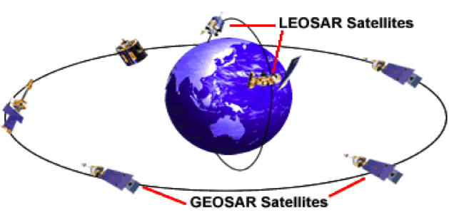
The Cospas-Sarsat system is currently comprised of two types of satellites, Low Earth Orbit (LEOSAR) and High Earth Orbit (GEOSAR). Low Earth Orbit satellites are placed close to the Earth, this coupled with the speed they need to circle the earth in order to stay at a constant altitude, causes them to rapidly fly over the terrain below. High Earth Orbit satellites because they are so much higher in altitude move at a speed in relation to the ground below which causes them to remain stationary over one spot on the Earth.

LEOSAR and GEOSAR Satellites

Low Earth Orbit Satellites orbit the Earth in near-polar orbits. They provide complete, yet non-continuous coverage of the Earth. The non-continuous aspect of the coverage occurs because the polar orbiting satellites can only view a portion of the earth at any given time.  Consequently the System cannot produce distress alerts until the satellite is in a position where it can “see” the distress beacon.  However, the satellite’s onboard 406 MHz processor includes a memory module, the satellite is able to store distress beacon information and rebroadcast it when the satellite comes within view of a ground station, thereby providing global coverage. A single satellite, circling the earth around the poles, eventually views the entire surface of the Earth.

Low Earth Orbit Satellites calculate the location of distress beacons using Doppler processing techniques.  Doppler processing is based upon the principle that the frequency of the distress beacon, as “heard” by the satellite instrument, is affected by the relative velocity of the satellite with respect to the beacon.  By monitoring the change of the beacon frequency of the received beacon signal and knowing the exact position of the satellite enables the calculation of the beacon location.

Each satellite makes a complete orbit of the earth around the poles in about 100 minutes, traveling at a velocity of 7 km per second. The satellite views a “swath” of the earth of approximately 6000 km wide as it circles the globe, giving an instantaneous “field of view” about the size of a continent. When viewed from the earth, the satellite crosses the sky in about 15 minutes, depending on the maximum elevation angle of the particular pass.

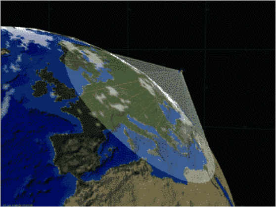
A LEOSAR Satellite Over-Europe
A Low Earth Orbit Satellite passing over Europe

High Earth Orbit Satellites carried on board various geostationary satellites. Because a high earth orbit satellite remains stationary relative to the Earth it has a continuous view of the terrain below enabling immediate alerts upon distress beacon activation. Unfortunately because the satellite does not move in relation to the terrain below there is no Doppler effect on the received frequency, and Doppler radiolocation positioning techniques cannot be used to locate distress beacons. Position information must either be acquired from the beacon though an internal or an external navigation receiver (GPS) and encoded in the message sent by the beacon, or derived, with possible delays, from the low Earth orbit satellite system.

There is one significant advantage of buying a beacon with a GPS receiver.  These emergency beacons determine their location using a GPS receiver that is either integrated into the beacon (called a location protocol beacon) or fed by an external GPS receiver. This accurate location information (generally around a football field in size for positional accuracy) is then encoded into the 406 MHz signal that is transmitted by the beacon.  The satellite then receives that signal with the location and forwards the location.  This information can often be derived in a matter of minutes!  Since every second counts in reaching the scene of a distress this means that there is an increased chance of survival.

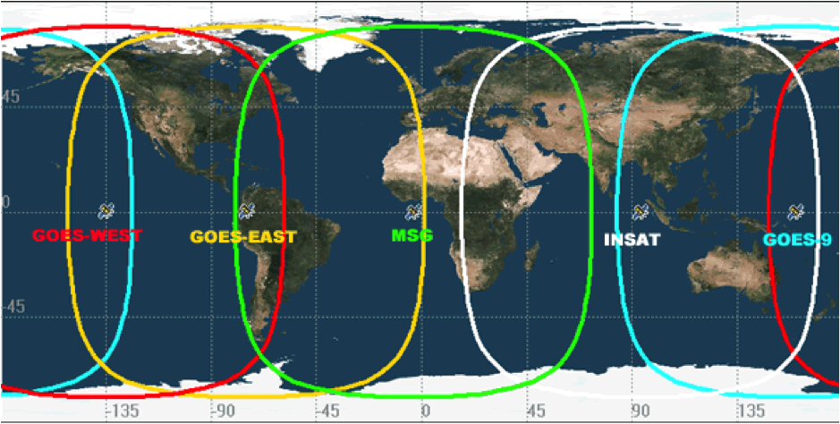
GEOSAR Satellite Coverage (Footprint)
High Earth Orbit Satellites are “parked” over the indicated positions and have a continuous view of their respective color coded line of sight areas.

The important points to take away from this are:

Low Earth Orbiting Satellites can provide position calculation on distress beacons which do not provide their GPS location, but a satellite has to pass over to hear the beacon. Remember Low Earth Orbit Satellite coverage is not continuous so delays in picking up a beacon are possible and it could take several satellites passing over before a accurate position is determined.

High Earth Orbit Satellites provide instantaneous detection of distress beacons in their field of view but cannot determine location on its own. The distress beacon must send an encoded GPS location to be forwarded to rescuers.

The LEOSAR and GEOSAR satellites are complimentary systems. Each type of satellite is able to help fill the others blind spots. While low Earth orbit satellites pass over areas every hour and a half or so the high Earth orbits are always watching. When distress beacons like PLBs are in an area where a satellite in high Earth orbit can’t see due to the angle or obstructions a low orbit one will pass over in time.


This site recommends that you buy a PLB with GPS capability!

Filed Under: SARSAT

Primary Sidebar

PLBs Save Lives

  • Boy Scout Leader with Heart Trouble Rescued by PLB
  • Colorado Hiker Saved by PLB

Beacon Reviews

  • 2022 ACR ResQLink Review
  • ACR Aqualink Review
  • 2022 ACR ResQLink View Review
  • 2022 McMurdo Fast Find 220 PLB Review

Recommended Accessories

  • Our Recommended Survival Accessories

Recent Posts

  • Colorado Hiker Saved by PLB
  • Boy Scout Leader with Heart Trouble Rescued by PLB
  • How and Why to Register Your Personal Locator Beacon
  • How do I test my Personal Locator Beacon?
  • How Do PLBs Work

PLB Information

  • Personal Locator Beacon Articles
  • Contact
  • Privacy Policy
  • Disclosure
  • Copyright

Categories

  • Personal Locator Beacons
  • PLBs Save Lives
  • SARSAT

Contact | Marketing Disclosure | Privacy Policy | Copyright Statement

U.S Military Veteran Owned Business

FTC Disclosure of Material Connection: In order for us to maintain this website, the links in the post above may be affiliate links.